- REVIEWS
Camera Reviews 
More Reviews Mobile Reviews Photography Reviews - GALLERIES
- VIDEOS
- BUYER'S GUIDES
Earth as Art
|
A Unique Photographic Perspective of Our Planet
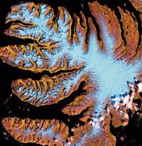
The U.S. Geological Survey (USGS) and the National Aeronautics and Space Administration (NASA) have collaborated on a joint initiative called the Landsat project, which has resulted in a collection of stunning images that provide a unique photographic perspective of our planet. The accompanying images are part of the "Earth as Art" Gallery, captured by the Landsat-7 satellite; the latest in a series of satellites that have been working around the clock since 1972 to document Earth's ever-changing landscape. The primary objective of the Landsat Project is to collect data and imagery of Earth's land mass, coastal boundaries, and coral reefs; providing accurate scientific data for monitoring changes in Earth's land surface and environment. The Earth as Art Gallery highlights specific images that were selected on the basis of aesthetic appeal, with the goal of introducing the general public to the Landsat Program. The Landsat-7 satellite was launched on April 15, 1999, and orbits the earth at an altitude of approximately 438 miles. The spacecraft is about 14 feet long and nine feet in diameter, and records reflected or emitted energy in the visible and IR wavelengths. These recorded responses are then converted to photographs by the USGS Earth Resources Observation Systems (EROS) Data Center in Sioux Falls, South Dakota. EROS maintains the national archive of remotely sensed images of Earth, and distributes this data to scientists, policy makers, and educators worldwide. Data is used to study land cover features, urban growth, and the effects of natural and man-made alterations to the land forms. Each image in the Earth As Art collection covers an area of about 115x115 miles, with the smallest identifiable feature about the size of a tennis court. The images you see here were selected for their photographic appeal, rather than for their scientific value. You can view the entire Gallery online at http://edc.usgs.gov. The EROS Data Center offers high-quality 26x27-inch color prints for $30. For more information, or to order prints, contact the EROS data Center at 800/252-4547. |


![]()
Get the Latest Photo Tips, News & Reviews from Shutterbug!
| Camera Reviews Other Reviews | Mobile Reviews Photography Reviews Columns | News | Features | How-To | Resources |
 © 2025 Shutterbug
AVTech Media Americas Inc., USA
All rights reserved