
Photographers have big chance to capture and take wonderful pictures when they go on traveling as they can discover many things along the way. - All State Van Lines Relocation
- REVIEWS
Camera Reviews 
More Reviews Mobile Reviews Photography Reviews - GALLERIES
- VIDEOS
- BUYER'S GUIDES
Locations: Photographing Peru’s Nazca Lines: A “Bucket List” Locale
Photographers may not admit it, but most have a “bucket list” of images they’d like to collect.
And photographers who also love to travel are probably most prone to this collecting imperative. High on my list was Peru. For those who have traveled there, Machu Picchu was probably a primary destination. And why not? Machu Picchu is one of the few Incan sites to remain essentially intact following the 16th century Spanish conquest of the Kingdom of the Incas—for the simple reason that the invaders never found it. Some 80 percent of the citadel’s buildings perched atop an 8000-foot peak remain standing. Its narrow agricultural terraces still march down the mountainsides toward the raging Urubamba River 2000 feet below.
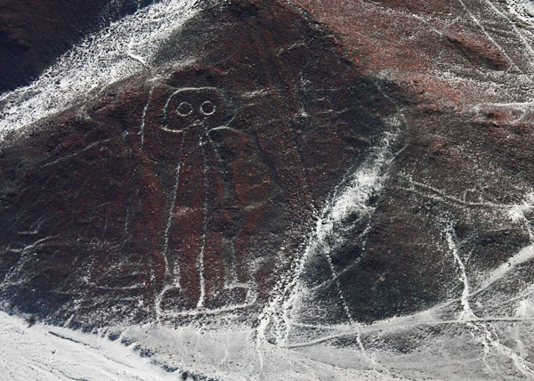
A figure known as “The Astronaut.” Unlike other figures drawn on flat surfaces of the Nazca Plains, this figure is inscribed on a hillside.
All Photos © Lorin R. Robinson
All Photos © Lorin R. Robinson
But while that was certainly a place for me to visit and photograph, my passion—and one that’s less commonly photographed—is the mind-blowing Nazca Lines. Located a six-hour’s drive south of Lima between the Pacific and the Pan-American Highway, they are among the most mysterious prehistoric artifacts in the world. After 80 years of intense study, how they were made and why is still the subject of archeological debate.
Imagine 40 square miles of one of the driest deserts on Earth. Imagine that hundreds of figures—many multiple football fields in size—of animals, insects, and flora along with geometric shapes and miles-long ruler-straight lines were inscribed on the desert floor over 2000 years ago. Imagine that the animal and insect figures are so carefully drawn that zoologists and entomologists not only can name them, but can identify particular species—some of which are not now or never have been native to the region.
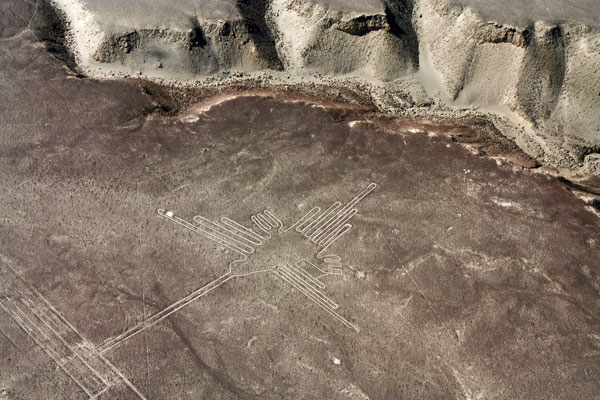
The hummingbird drawing has become a Peruvian national symbol and appears on its currency.
The existence of the Nazca Lines didn’t become widely known until the early 1930s when air routes opened south of Lima. If the light was right, pilots and passengers were astonished to see a jumbled zoo of figures spread below as their lumbering DC-3 slowly traversed the Nazca Plains at relatively low altitude.
With the discovery came archeologists from far and near bent on answering questions swirling around the huge tapestry. Who made the figures? How were they made? What purpose did they serve?
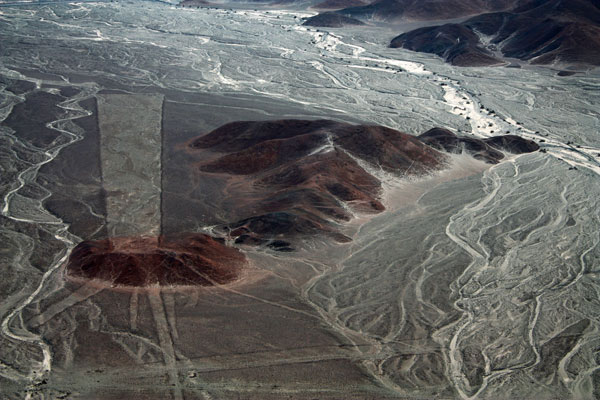
Consensus has been reached on only two points. They were constructed over 2000 years ago by the indigenous Nazca people. But only half of the “how” is understood. Several millennia ago, volcanic activity in the region spread a thin layer of dark ash over the desert’s white alkali. The builders “simply” had to punch through this layer to inscribe the figures.
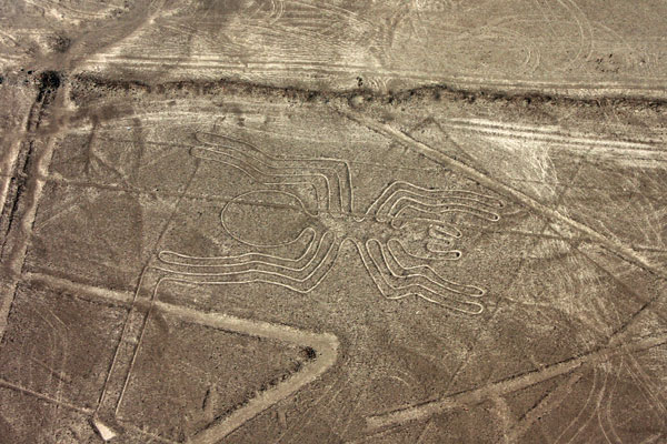
The drawing of this spider is so accurate, entomologists were able to identify its genus and species.
The other half of the “how” is more difficult to explain. How did a primitive people without basic mathematics or surveying equipment draw such enormous, accurate, and proportionately correct figures on the desert floor—without being able to see what they were doing?
Interesting—though widely discredited—answers have been proposed. Have you heard the one about the Plains of Nazca being a spaceport for visiting aliens? This was Erich Von Däniken’s explanation in his 1968 book Chariots of the Gods. The presence of a figure uncannily resembling an astronaut gave some credence to his notion. Then there’s the theory that the early Nazcans invented hot air balloons constructed with sheepskin in order to survey the work from above. A scientist actually built a balloon using local materials. His flight lasted two minutes.
The other question still being debated is why the Nazca people spent so much time and energy making the figures on that scorching desert floor. The theories fall into three categories—astronomical, religious, or to provide maps to sources of water.
Geometric figures, often trapezoids, are common on the Nazca Plains.
While the debate continues, the figures are there to be photographed—from the air, of course. A local flying service offers 30-minute ($130 US per person) or one-hour ($260 US per person) flights, from 8am to 4pm, seven days a week, out of Nazca’s small local airport. Included is transportation to and from your hotel if needed and an introductory video. The six-passenger high-winged Cessnas provide good, if fast, over flights of the major drawings. (For more information, visit www.mysteryperu.com/eng/co_nazca_lines.html.)
Oh, and one note about post-processing. When you first view your images, don’t be alarmed if they look flat and almost monochromatic. Some basic work in Photoshop or your favorite editing software can make the lines pop—assuming you were working with decent lighting conditions. Improving contrast and color saturation is about all that should be necessary.
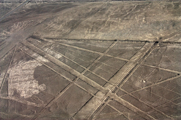
Several groupings of intersecting lines give the impression of airport runways and taxiways.
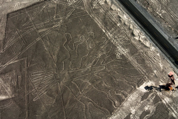
The two-story tower (lower right) was built along the Pan-American Highway to provide low-level views of two figures, including The Tree.
Photographing From The Air
Here are some shooting tips for those photographing from light planes, gleaned from my Nazca flight experience:
* Expect lots of fast, tight turns—some with banking up to 60 degrees. The pilot will approach a figure from one side, bank and return for the benefit of those seated on the other side, and then go full throttle on to the next figure.
* Views are pretty good from all windows, but the seat to vie for is the co-pilot (right) seat. All the controls have been removed, providing plenty of room.
* Shoot with a wide-angle lens—24-28mm is best. Even at 2000 feet, the drawings are huge. Since your focus will be infinity and depth of field is not an issue, use the fastest shutter you can under existing lighting conditions. Also, it’s best to set the camera on manual focus to avoid potential autofocus issues.
* Plan your flight for early or late to take advantage of the low-light angle. In addition to providing better contrast, early or late light warms up what is essentially a dun- or gray-colored landscape.
* Bracketing is a good idea. Not only will it increase chances for a good exposure, but three quick shots may help you get the image in the frame on one of those high-banked turns.
A view from a tower bordering the Pan-American Highway shows how the Nazcan builders incised the lines through volcanic ash to the lighter desert floor beneath.
- Log in or register to post comments


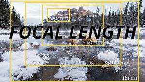


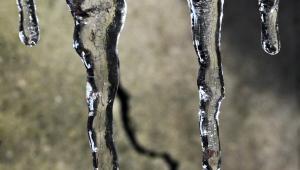


PHOTO OF THE DAY
Today’s photo is Cold Weather 'Dogs' by Hans B. Epp
eNEWSLETTER SIGNUP
![]()
Get the Latest Photo Tips, News & Reviews from Shutterbug!
| Camera Reviews Other Reviews | Mobile Reviews Photography Reviews Columns | News | Features | How-To | Resources |
 © 2025 Shutterbug
AVTech Media Americas Inc., USA
All rights reserved